How Smart Fishing Spots Saves You Time Out On The Water
- By: Richard Thomas
- on
Did you know that Smart Fishing Spots saves you time out on the water???
The Routes & Tracks Feature has helped me accurately map out my trips so I am not wasting time on the water and if the weather changes, I can make my way back home safely.
Check this out!!
How Smart Fishing Spots Saves You Time [VIDEO]


Routes & Tracks are extremely helpful, especially when traveling long distances or you fish in areas with huge tidal shifts with a lot of water moving in and out.
Understanding how to use Routes & Tracks can help you navigate in tight areas where you need to follow an exact path to a spot.
Georgia Example
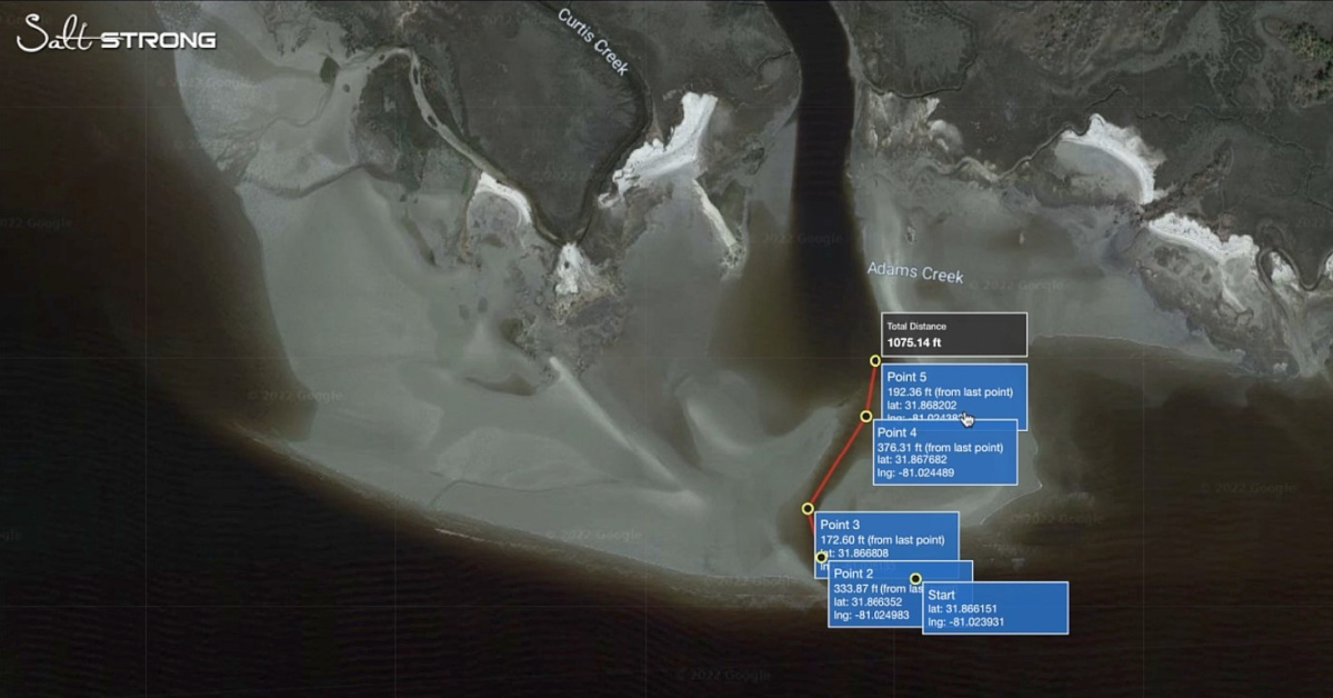
Recently, I was out fishing some cuts and coves during low tide, but the issue was gaining access to the spots I had picked out.
My access point to these spots is a very narrow channel.
There are sand bars and structure surrounding this super skinny winding channel on both sides.
With heavy winds and breakers crashing on sand bars, it can be difficult to pinpoint exactly where the channel even begins.
So I ended up using Routes & Tracks to save the path I made traveling through the channel for the next time I fish here.
Routes & Tracks
On the Smart Fishing Spots App, click the Blue “Gear” icon in the bottom right-hand corner of your screen to open further menu options.
Then, select the third icon from the left that looks like two waypoints with a line drawn between them indicating the “Routes & Tracks” tab.
Make sure you are open to “Routes” and then select “New”.
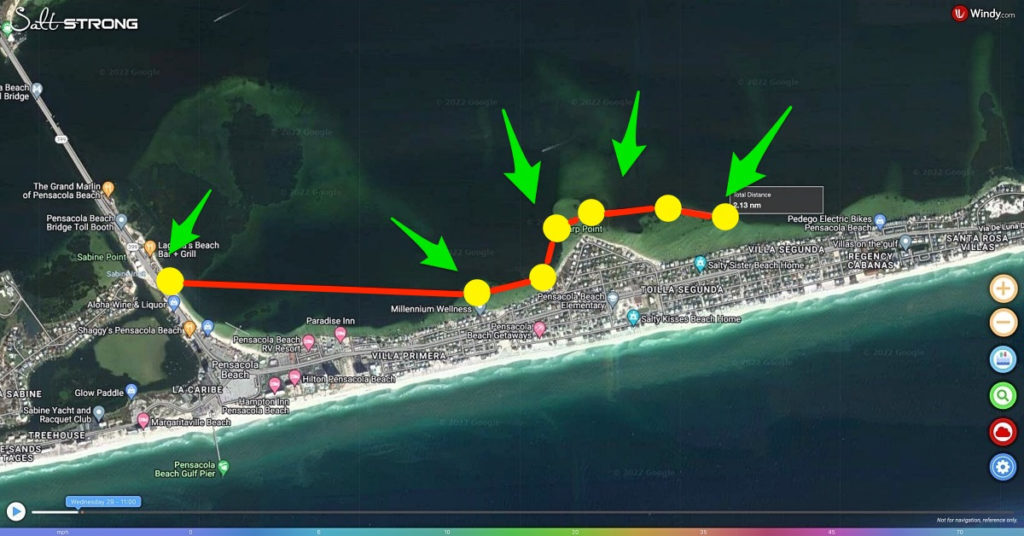
Immediately, your cursor will change and you can now drop and drag your waypoints to create a route.
Once you click anywhere on the map, a waypoint is created with the latitude and longitude of that exact spot.
If you have a GPS device, then you can transfer this information there as well.
When you’ve finished mapping out your route, go ahead and click the green button to finish that route.
You can then do a few things with this information.
You can either save the route to have that safely in Smart Fishing Spots or you can right-click the route and click “Send To Your Devices”.
Smart Fishing Spots gives you the option of transferring this data directly to your phone or tablet with the click of a button.
Now the track you created on your desktop or laptop is available on your phone out on the water.
The time saver in all of this is you can access these spots at any time.
You don’t have to wait for natural indicators of the channel to reveal a path to backwater fishing spots.
You have the GPS coordinates and route mapped out already to safely navigate any channel at any tide stage.
It is much safer than you trying to navigate questionable channels on your own.
Conclusion
Smart Fishing Spots can be used in a plethora of ways not just to find fish or to monitor the weather!
Now instead of waiting for water to fill in a channel so you can cross or looking for natural indicators of a safe path, you have the answers already in Smart Fishing Spots.
We’re here to save you both time and money while helping you catch more fish!!!
Do you have any more questions about how Smart Fishing Spots saves you time out on the water?
Have you used this feature on Smart Fishing Spots yet?
Let me know what you think down in the comments!
If you know someone who wants to learn more about how Smart Fishing Spots saves you time, please TAG or SHARE this with them!
Oh, and if you Join the Insider Club TODAY, Smart Fishing Spots is absolutely FREE! Click here to join us in the Insider Club!
Related Articles:
Related categories:
STOP WASTING TIME ON THE WATER!
Do what the “SMART ANGLERS” are doing and join the Insider Club.
Here’s what you’ll receive today when you join:
- Weekly fishing reports and TRENDS revealing exactly where you should fish every trip
- Weekly “spot dissection” videos that walk you through all the best spots in your area
- Exclusive fishing tips from the PROS you can’t find anywhere else
- Everything you need to start catching fish more consistently (regardless if you fish out of a boat, kayak, or land).



Is there a tutorial on how (if possible) you can use the smart fishing app on your cell phone to identify your current boat location and guide or direct you to a specific lat/long location such as an offshore reef?
Hi Richard I have no problem building the Route but I can’t seem to find where I can turn on Location Services on my iPhone 12 mini. As Salt Strong is not an “APP” on my phone but a website interface where do I turn on location services to see my boat position relative to my created route? I thought by turning on my browser location services e.g., Google, Safari and Duck Duck Go would be the answer but it didn’t work. Having the route is great but if I can put my position on the route it’s not as valuable. Can you assist?
Great video on how to use the app. Having a problem though – I’m not seeing the option to send the route to my phone. I’m using Chrome and have an iPhone13. What am I missing?
Thanks again for all of the tutorials.
No Problem Rodney! So I also have a MAC/ APPLE computer that is already linked to my phone, so thats how I am able to send it straight to my phone. If you have a PC that isn’t connected Via Bluetooth this feature may not work. You can still save it to you simcard and put that into your GPS unit however.
If not you will just have to keep it on your phone as a saved track. Hope that helps!
10-4 – Thanks for the response – this helps me out.
Greetings
I don’t know if it’s included in the app but you guys should include launch spots for kayaks and boat ramps
Cool route saving trick Richard!
Thanks Luke!
Excellent tip and instructions, Richard!
Appreciate it Rob! Loving all the features and tricks on this platform so far and wanted to share!