The Importance Of Planning Routes On Inshore Fishing Trips
- By: Tony Acevedo
- on
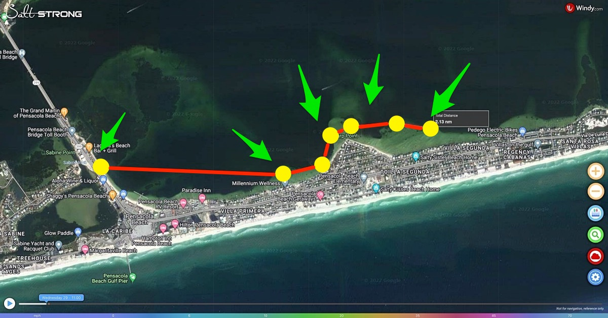
Are you planning routes on inshore fishing trips?
Why is pre-planning a route important to inshore fishing?
Planning a route while inshore fishing can be way more useful than you’d think and can help you fish where you want without relying on only your memory of where you plotted spots.
Learn more about planning routes using Smart Fishing Spots here!!
Planning Routes On Inshore Fishing Trips [VIDEO]

Planning your route is popular amongst nearshore and offshore anglers that fish open water and need guidance to navigate to their pre-chosen spots.
But planning a route on an inshore trip can definitely help you as well because you may not always remember where spots are on the map.
Planning your route will help you have spots pre-selected for fishing and it can help create a safe navigable route for your trip.
Smart Fishing Spots is a new platform we created that is an All-In-One Fishing App.
You can see the tides, wind, and other weather factors in one space along with contour maps, shaded-relief layer maps, and much more.
Simply, you can delete all of your fishing apps.
We are also constantly adding new features and ways to help you catch fish that no other app is capable of.
If you are not an Insider Member yet, you’re going to want to get into the club sooner rather than later!!
Planning Routes On Inshore Fishing Trips Example
Once you open Smart Fishing Spots, you will see the base screen that shows the wind data from Windy.
In the bottom right-hand corner, there is a menu bar and on the bottom of that menu bar there is a blue icon that looks like a small gear.
Click that and it will open a further menu that you use to toggle between maps and different settings.
Select satellite view and then find the area you plan on fishing.
First, you need to find an area to launch your vessel from.
Once you know where you are launching from, go ahead and click on the third icon from the left on the pop-up menu in the bottom right corner.
It looks like two waypoints with a line drawn between them representing a route and this is the “Routes and Tracks” tab.
Once you open Routes and Tracks, click on “New” and your cursor will turn yellow and a message saying “Click to start drawing line” will appear.
Next, click once on the area you’ve chosen to launch your vessel from and slightly zoom out.
Now, you can start looking for spots you want to fish.
When you come across a spot that looks interesting, click once over it and it will be added to your route.
After you have chosen the spots you want to include on your route, go ahead and click “Finish Route”.
Go back over to Routes and Tracks and then click “Save”.
Then you can name the track and have it saved into Smart Fishing Spots.
You are now able to clear the route and then open it when you want to by selecting “Load” under Routes and Tracks.
A drop-down menu will appear with your previously loaded routes.
Furthermore, you are able to export these routes to an SD card or other device and have them appear on your GPS unit on your boat.
Tracking Your Route
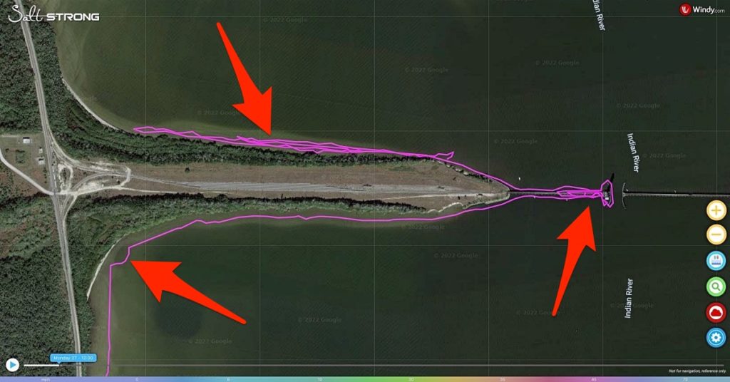
On top of being able to pre-plan a route, you can actually track your path on any fishing trip.
“Tracks” is located under Routes and Tracks.
You don’t want to hit record until you are out on the water about to start your trip.
Then that will start recording your track throughout the day.
You can see the route you drew out earlier and if your plan possibly changed along the trip.
This data is useful to compare what you planned previously to what you actually did out on the water.
[optin-monster slug=”wcrcrc7d6ih5k29wooi4″ followrules=”true”]
Conclusion
Smart Fishing Spots is already a critical part of our Insider Reports and has been incorporated into planning trips and led to further success by our Fishing Coaches.
This is just one more way we aim to help you catch more fish.
You won’t think about planning a fishing trip the same way you did before ever again.
Do you have any questions about planning routes on inshore fishing trips?
Feedback Needed!
Please share your thoughts and opinions on Smart Fishing Spots!
Has it helped you find fish?
What can be improved?
And if you know someone who wants to learn more about planning routes on inshore fishing trips, please TAG or SHARE this with them!
Oh, and if you Join the Insider Club TODAY, Smart Fishing Spots is absolutely FREE! Click here to join us in the Insider Club!
Related Articles:
Related categories:
STOP WASTING TIME ON THE WATER!
Do what the “SMART ANGLERS” are doing and join the Insider Club.
Here’s what you’ll receive today when you join:
- Weekly fishing reports and TRENDS revealing exactly where you should fish every trip
- Weekly “spot dissection” videos that walk you through all the best spots in your area
- Exclusive fishing tips from the PROS you can’t find anywhere else
- Everything you need to start catching fish more consistently (regardless if you fish out of a boat, kayak, or land).


I think you can export the routes and load them your fish finder so you do not have to use your cell data nor not to run out your smart phone battery. Very nice fishing app!
Will this tracking help if you don’t have a boat and etc. parking is not available at a lot spots I want to fish can it show me the the walking distance and etc
Absolutely! Just have to be aware that it does rely on cell service right now so if you get to an area that is sort of off the grid with no cell service it will stop tracking.
This is a great tool. Actually, I think the relief shading goes beyond anything available ive ever seen. Wow!!
What happens to a track being recorded when you move into an area without cellular service? Is the track, route, map, or any part of the app function available when outside of cellular service range? In my area, there are gaps in cellular service, so I want to be ready. Also there is going nearshore/offshore. Also I go on fishing trips to south LA in the maze of marshes out of Venice, LA, and there often is no cellular coverage there. Are there any plans to be able to record small sections of the nautical navigation map so you will at least have that whe out of cellular range?
Unfortunately right now it will lose your track if your cell service cuts out, and also if you close the window at any point while using it (due to privacy/security as its web based). We are constantly working to make it better and eventually be an actual app that can be downloaded.
Thanks Tony. Pleased to hear the objectives. The app is so good now; Fortunately the cell service is surprisingly good over Choctawhatchee bay where I fish a lot!
I love this! Thanks Tony!!
You’re welcome Scott!
I’m loving the on the job training videos! Thank you, Tony!
You’re welcome Anthony!
Thanks, Tony! Nice feature and well explained.
EDIT: I found the Tracks tutorial here: https://saltstrongdev.wpengine.com/fishing-tip/smart-fishing-spots-tracks-tutorial/
You’re welcome John and thank you!
I’ve used the app and I like it. I really like the addition of the “hot spot” layer/identifiers. This video is particularly helpful by illustrating that you can pre-plan a route to the hot spots. That’ll be helpful once on the water. Thanks for posting, Tony! Looking forward to more features being added.
My pleasure Randy!
Thanks Tony! Is there a function to create a waypoint using coordinates? In other words, could I type in a specific lat/long and mark the point on the map? Thinking in terms of nearshore reefs and whatnot.
You’re welcome Christian! Not at the moment but i’m sure it can be added! We are constantly making updates so I’ll mention that to the team for sure!
Track + Route = Trout
Haha Tony always has fish on his mind! Gotta love it
Haha I like what you did there!
TY for sharing how to get the most out of the new app/technology.
You’re welcome Heath!