How To Plan Your Next Fishing Trip With This New Fishing Forecast Website
- By: Luke Simonds
- on
- Found In: Fishing Tips, Inshore Fishing, Weekly Newsletter: 11-10-19
I used to dread planning fishing trips.
I’d have to pull up different apps for tides, weather, and satellite maps, and then sift through a bunch of pages and popups to get the info I wanted.
And then I’d have to take all that info and guess what time will be best for fishing.
Now, not only is all of that condensed into one website (SmartFishingTides.com), but once I find the tide station I’m looking for, it’s condensed into just one page!
And I’m told exactly when are the best times to fish that day.
In this video, I’m going to show you how to plan your next fishing trip in just a few short minutes using just your phone and one website.
Let’s dive in!
Using Smart Fishing Tides On Your Phone [VIDEO]
Keep reading to see how I plan my fishing trips with Smart Fishing Tides.
1. Select your tide station
You can select your tide station by clicking on the Smart Fishing Tides logo that marks each tide station.
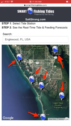
Once you click on a tide station, you’ll go to that station’s page where you’ll be able to get all the information you need about it, starting with the Strike Score.
2. Check the Strike Score to see which day is best to go fishing
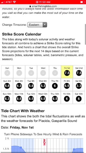
Based on factors like the weather, solunar activity, barometric pressure, and tides, the Strike Score will tell you when the best days to go fishing are on a 1-10 scale (1 being the worst day, 10 being the best).
3. Check the tides
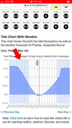
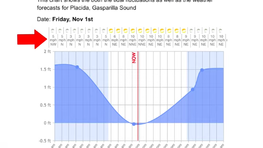
After you decide which day to go fish, you can scroll down to check the tides to see tide height and current.
4. Check the weather and tides together
If you turn your phone horizontally, you’ll be able to see hourly weather and tides together, to help you get a good understanding of the conditions.
5. See hourly feeding level projections
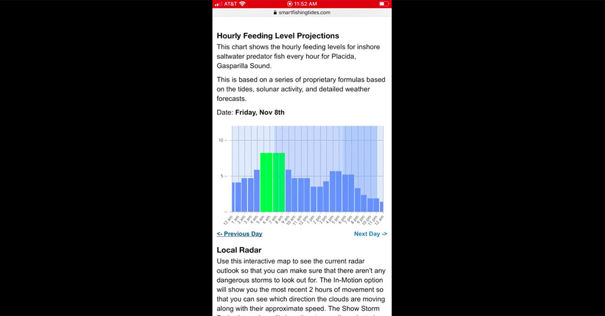
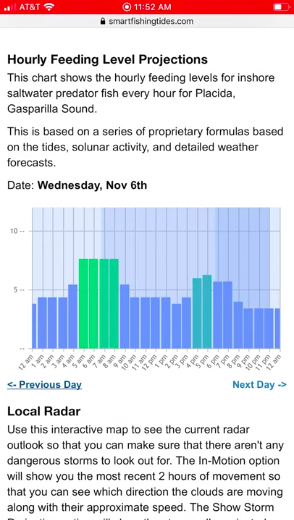
Scrolling down from the tides section, you’ll be able to see the hourly feeding level projections to help you determine when to go fishing.
6. Check local radar
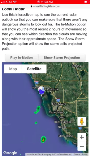
On the day of my fishing trip, and during my trip, I’ll check the local radar to see if there are any storms in the area.
Just click the show radar button and the radar will populate.
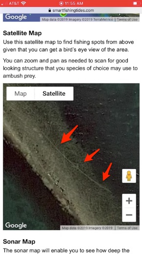
7. Check the satellite map
Checking the satellite map is not only good for planning a trip, but is also helpful for navigating safely.
In the second image, you can see prop scars on a sand bar.
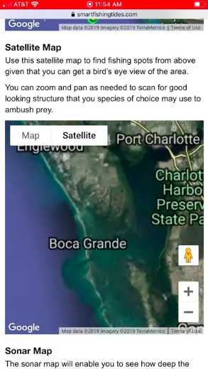
Check out the prop scars on the image below, and if you want more info about using online maps to navigate shallow water, check out this article.
8. Check the sonar map
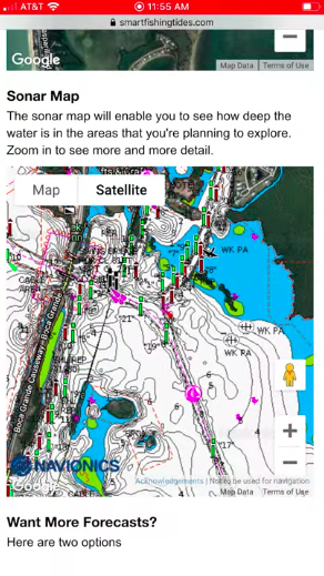
If you’re fishing in murky water, or deep water and you can’t see the depth change on the satellite map, you can use the sonar map.
Website vs. App
A lot of people have asked if this will be an app.
For now, the answer is no.
There are several advantages of this being a website and not an app, such as when we make updates they’ll automatically be there (as opposed to you having to update the app yourself), and you don’t need to download it on your phone.
The main reason people seem to want this as an app is that they want to be able to quickly access it from their home screen.
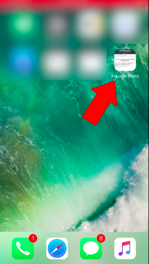
Check out the steps below to learn how to add this site to your home screen for iPhones just like an app.
P.S. You can do this with multiple tide stations so you can quickly access each of them (another advantage of this being a website and not an app).
How to put a tide station page on your iPhone home screen
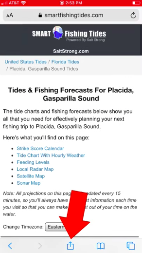
1. Go to the tide page, scroll down, then click the box with the arrow coming out of it
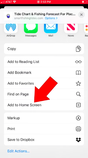
2. Scroll down and click “add to home screen”
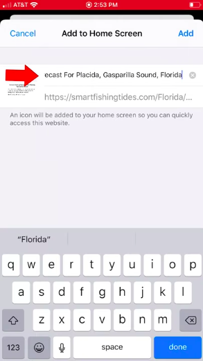
3. Rename the icon by clicking the top box
In this case, I named my icon “Placida Tides.”
Conclusion
I hope this makes planning fishing trips easier for you!
Do you have any questions?
Or any suggestions to make it better?
Let me know in the comments!
And please share this with your fishing buddies!
P.S. Want the best local fishing spots, discounts on fishing gear, and to stay up to date with what and where the fish are biting right now? Join us in the Insider Club!
Do You Want To Quickly Find New Fishing Spots In Your Area?
Then you’ve got to see this private fishing club!
Here’s what you’ll receive today:
- Weekly fishing reports and TRENDS revealing where the inshore fish are feeding all year long
- Weekly “spot dissection” videos that walk you through all the best spots in certain areas
- Exclusive fishing tips from the PROS you can’t find anywhere else
- Everything you need to start catching fish more consistently (regardless if you fish out of a boat, kayak, or land).
Click here to join today.
Related articles:
Related categories:
STOP WASTING TIME ON THE WATER!
Do what the “SMART ANGLERS” are doing and join the Insider Club.
Here’s what you’ll receive today when you join:
- Weekly fishing reports and TRENDS revealing exactly where you should fish every trip
- Weekly “spot dissection” videos that walk you through all the best spots in your area
- Exclusive fishing tips from the PROS you can’t find anywhere else
- Everything you need to start catching fish more consistently (regardless if you fish out of a boat, kayak, or land).


 Go to SmartFishingTides.com
Why don’t the daily strike scores and the hourly feeding projection seem to correlate? I am looking at Seadrift Texas for example, and this Friday has a higher daily scores than Thursday, but the hourly feeding scores look better on Thursday.
Those two metrics are not directly tied to one another… the daily score is a measure of the overall day compared to other days in the 14-day window. And the hourly score is focused on highlighting the hours that are likely to have the best feeding activity compared to other hours that given day.
I really liked this site, but seems like now we have to pay for it?
What is holding you back from joining the Insider Club? It comes with a guarantee that you’ll be catching more inshore slams than ever before while saving money on your tackle. Here’s a link to learn more about it: https://saltstrongdev.wpengine.com/pricing/
On the sonar screen, what does the blue areas indicate?
The blue zones represent very shallow water.
Thanks.
I must be doing something wrong. I have a XS Max I-phone. When I pull up the station I want to save I shift the screen and the box with arrow does not appear. The typical bar with the back, forward, search, and how many pages shows up. Thanks Joel
That’s odd. The feature you need to find is “Add To Home Screen”, so the best option may be to search YouTube for that plus your phone model. Sorry I can’t help any further (I don’t have access to that model so can’t troubleshoot the issue).
Hello Luke,
This looks to have great potential for people like me, who are not Florida residents (Georgia in my case) and are targeting fishing opportunities in somewhat limited time/location trips to Florida. By the way, except for a dinner fish or two, these are catch-and-release for Florida trips. I think at least one adjacent state might look to Florida regulations to provide some guidance to options for sustainable sport fishing for nice fish versus meat fishing for small trout and red fish (Georgia still seems to weigh in on the latter in my opinion — gotta fill a cooler for a good trip).
A couple of questions:
1) What are the parameters that go into the “bite time” algorithm or whatever you call that (solunar calendars?) and how is adjusted with weather conditions? Is this only for the primary tidal stations in given area or for the subordinate stations as well?
2) How will you evaluate the “skill” of this model at different times/conditions and in different places?
I realize question (2) will be difficult to quantify, but maybe your feedback network can provide a basic idea. I suspect this is your expectation, but maybe a way to record before/after trip predictions/results would help for this.
Overall, this looks to be building on one of the Salt Strong focus areas that I appreciate; providing a solid basis for trip planning.
Jim Nelson
Hey Jim, please know that this new tides platform works for any state along the Atlantic and the Gulf with redfish, seatrout, flounder, and/or snook (not just a tool for fishermen who fish FL waters).
The parameters are complex and they’ll be adjusting over time based on the season and how we see the score performing each week. It includes tides, solunar calendars, wind speed/direction, temperature changes, pressure changes, time of day/night, etc.
We’ll be continually evaluating the model for accuracy over time based on our own findings as well as from feedback we get from Insider Club members… so far, the results have been very good (the feedback has surpassed all of our expectations for this early in the platform’s life).
Thanks for the reply Luke. I spent an additional hour or so trying out the platform earlier today and I am very impressed with the functionality. My impression is that your team has done a thorough job testing this before release. From my initial look: pretty easy navigation; no glitches (e.g., satellite and bathymetry zooms for my selected areas to maximum resolution); and very clearly integrated information. I think it really appears to be working as intended. I focused on a few areas where I have experience around Savannah (previous years with a boat, recently kayak and shore fishing), north and south Mosquito Lagoon, and Placida FL (kayak fishing for FL). This looks like a great compilation of information for planning a trip and I’ll look forward to testing it in new areas.
One question: maybe I missed this, but what is the range for “score” (0-10) and what do various scoring levels mean? I realize that incompetence and inexperience and level of distraction can dominate outcomes of fishing trips as much as the inherent variability of nature. So is this calibrated to you in your boat casting your favorite lure? If so, with or without the dog?
Why is it said that saltwater catfish are not good to eat
Saltwater catfish are generally known to be undesirable fish to catch.
Rumor has it that their meat is actually pretty good. I tried gafftopsail catfish once, and it was surprisingly good.
Awesome tool! Thanks guys. Looking forward to giving it a try. I am having one problem though. When I turn the tide chart sideways I do not get the weather/wind forecast. I am using an IPhone 9. Any ideas on how to correct this? Thanks.
Can you please let us know which specific phone you have? The way to find it is to go to:
1) Settings
2) General
3) About
4) What does is say on the “Model Name” line?
Thanks Luke. The model name of my IPhone is iPhone 7. Just to clarify, when I rotate my phone, the tide chart does not rotate with the phone with th egg weather/tide info on the heading of the chart or right side of screen. The tide chart does not rotate, it stays in the same view, just wider. Thanks again for your help.
Just visited the website and the tide charts for my area are now including weather and wind information. Great news! Thanks so much for your help.
Excellent news!
I have the same problem with my Kyocera E6910. I cannot get the wind and weather, but everything else works. Thank you for any help you can give with this issue.
Thanks for letting us know Lara! I just sent your issue over to our developer to troubleshoot the issue.
Hey Lara, the issue with the wind and weather should now be fixed. Please check it out when you get a chance, and let me know if you see any further issues. Thanks so much for the help!
Works great now! Thank you for your prompt attention to this matter.
Checked out the web site. Looks really nice, except all that works is the satellite maps which is really awesome, but would be super cool if all the functionality was there. Is that becasue it is in Texas? Only works in Florida for full functionality?
It should be working for the TX locations too. Which tide station are you using?
Good morning! I tried to look at tide charts in a few other states, including FL and the only thing that works is the satellite map view. I do have a couple of anti-trackers and ad blockers working on phone so could that be why there is no web site functionality? I need to try it on desktop but I have even more ad blockers, anti-virus, anti-trackers, all that stuff on my computer.
Keith: I’m in Texas. It was down for a little while last night, but is working now.
Most of the really good trout fishing sites in North Carolina are in the creeks of of the Pamlico Sound , Pungo , Pamlico and Nuse River . Where are the tide stations on the inner banks. We have caught our limit the last there trips up Pungo Creek.
It appears as if the service we use for getting the tide details does not have data for those spots. What do you currently use for getting tide intel there?
Great Website. I have been using it for the past couple of weeks. I do miss the comments after the scores. I loved showing my boss that on a day with a score of 9, I was advised to “Call in sick and go fishing!” She actually let me go once.
Great work guys!
Agreed lol
Thanks for leaving the helpful suggestion! We’ll be sure to add those comments back in hopes that they help you get permission to go fishing in place of work again:)