Which Is The Best Satellite Map For New Inshore Fishing Spots?
- By: Luke Simonds
- on
- Found In: Fishing Tips, Inshore Fishing

If you’re competitive like me, then you’re always seeking an edge of the competition… and this most certainly carries over to fishing.
For inshore anglers, the great news is that technology has opened doors to get a huge head start on finding the best fishing grounds… even well before you step foot out of your house.
I’m of course referring to using online satellite maps that allow you to probe the areas you plan to fish for important features that attract your target species.
Best of all, many of these online map resources are completely free of charge, so this incredibly valuable information is only a few mouse clicks away.
In this article, you will discover:
- How to assess new fishing grounds using satellite maps
- See the 3 most popular online maps compared against one another
- Google Maps for Inshore Fishing
- Mapquest Maps for Inshore Fishing
- Bing Maps for Inshore Fishing
- The answer to the following question we’ve been asked many times… which one of the free online maps is the best for inshore fishing?
Are you tired of fishing the same old spots over and over again?
Then watch this FREE webinar training where you will discover how to find the best inshore spots in your area.
Register here now (before the webinar goes down)!
What’s The Best Map For Inshore Fishing?
First, let’s briefly discuss the overall benefits of using online maps for inshore fishing… particularly when targeting redfish, snook, and big trout.
Overall, online satellite maps let you see what type of bottom contours exist in the areas you plan to fish, and they even allow you to see what type of structure (if any) is under the water in many cases.
The benefit of knowing the underwater contours and bottom structure of a fishing ground is that you’ll be able to see which particular spots are most likely to hold the most fish…
And just as importantly, you’ll be able to see which areas do NOT offer much fish habitat so you don’t waste valuable time on the water fishing in unproductive areas.
So before feeling overwhelmed when trying to use online maps, just keep in mind that fish most often have only two basic things on their mind:
- Finding food
- Not becoming food to something else
Knowing this, all we really need to do is keep these two simple factors in mind when looking at a satellite map for good fishing grounds.
The Most Important Features In Satellite Images
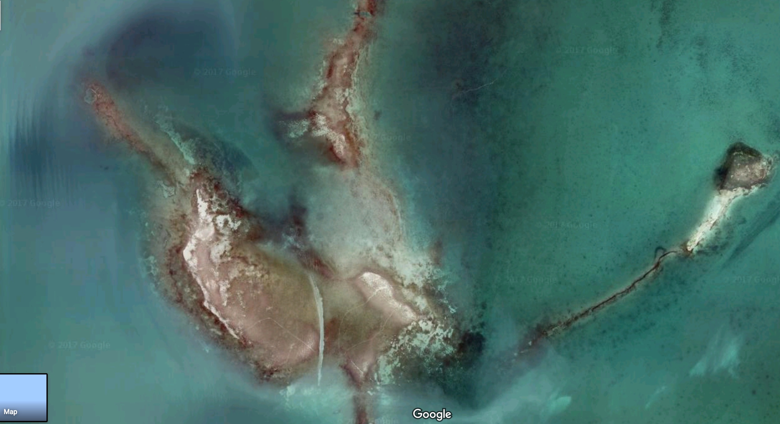
In order to not get overwhelmed when analyzing online satellite maps, it’s best to focus on the two most important factors that snook, redfish, and big trout relate to throughout the entire year:
1 – Underwater Structure
Knowing that all types of fish seek safety from bigger predators, it’s safe to say that underwater structure of any kind will often be a great hiding spot for small fish…
And the presence of small fish will, in turn, attract larger fish…
So underwater structure is one of the most important things to look for when using online satellite maps… here’s a quick list of the types of structure I look for when using satellite maps:
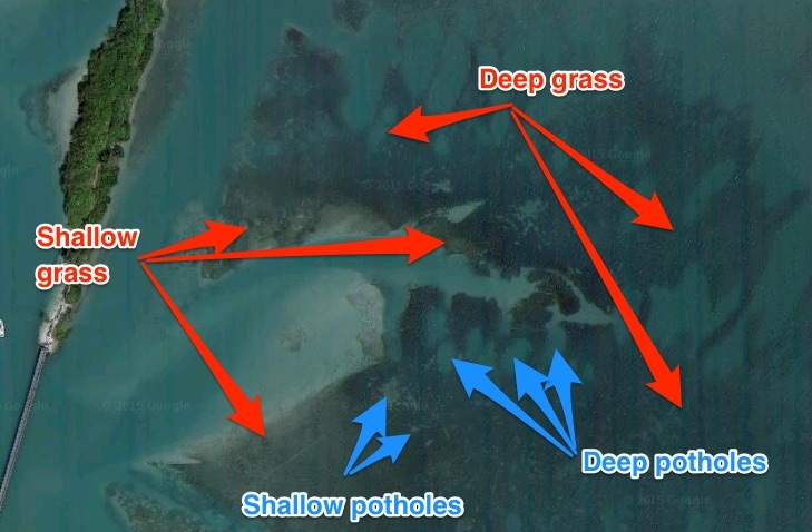
- Underwater grass
- Oyster bars
- Potholes in sea grass flats
- Docks
- Mangrove Trees
- Rock outcroppings
- Sunken boats or any other large item on bottom
Most importantly, it’s best to look for spots that contain more than just one of these items… the more the merrier!
2 – Underwater Contours
Just like humans, fish prefer to meet their needs while expending as little effort as possible. So most predatory fish often seek locations with the most current so their meals can be brought to them.
For this reason, it’s very important to be able to understand how to read bottom contours to be able to get a good idea of how much current flows through/across a particular area.
Fortunately, this is easy to do in many cases when looking for inshore fishing spots with satellite images because the areas with heavy current will almost always show clearly in the form of trenches on the bottom.
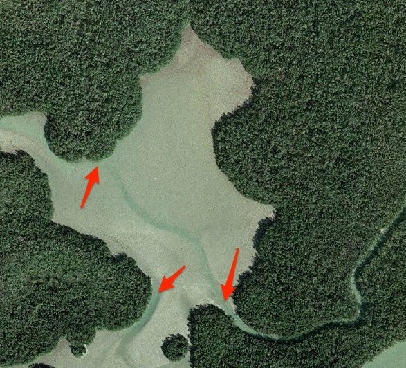
Another important reason bottom contours is important is due to the fact that snook, redfish, and big trout often gravitate towards different water depths depending on the time of the year as well as the time of day and even with the shift in tides.
For example, these fish typically move out towards the inlets/passes in the summer time, and they often start the day in feeding in the shallows, then move a bit deeper during the middle of the day before going back to the shallows in the evening…
And they’ll often move in and out with the shifting of the tides throughout the day.
So it’s smart to analyze the clarity of the bottom compared to other spots in order to get a good idea of the water depth of a particular area as well as nearby spots so you can be ready to follow their migration.
The bottom contour is the most difficult feature to distinguish using online maps, but you’ll get better over time… especially when you get comfortable using more than one map service.
Most Popular FREE Online Satellite Maps
The most popular Free online satellite maps are provided by:
- Mapquest
- Bing (in no particular order).
When I began using online satellite maps for fishing (about 15 years ago), I used Google exclusively.
Then I began exploring a lot of new areas around Florida and found that the bottom contour was sometimes tough to make out due to a variety of reasons… water clarity, glare on the water, etc.
So I began utilizing satellite maps from Mapquest and Bing whenever needed over the years and have found them all to have unique pros and cons.
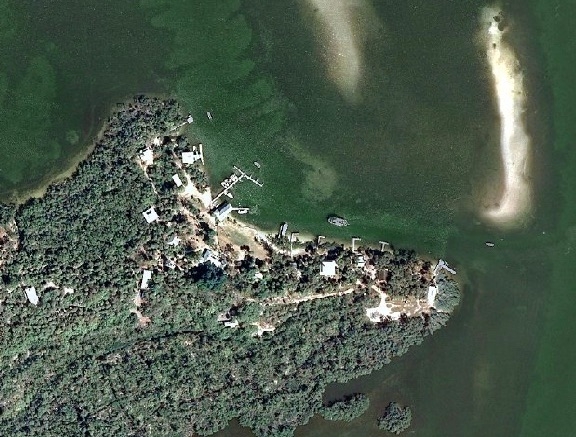
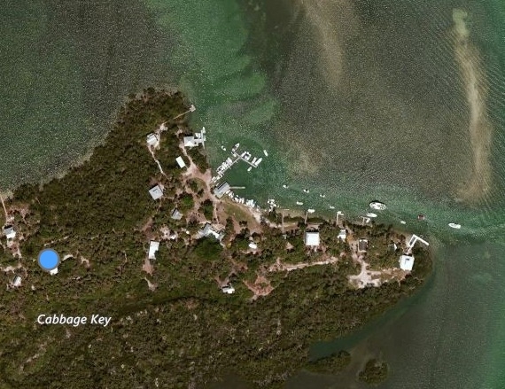
Here is an image of some popular areas from the three different maps so you can see their differences…
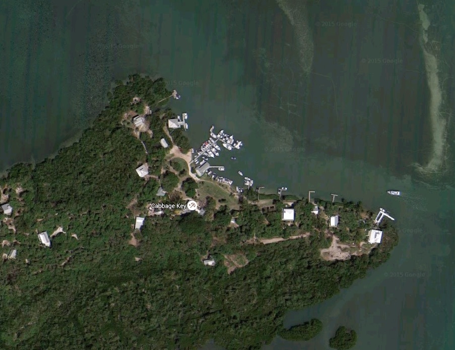
Satellite Views of Cabbage Key, FL
For this location, Mapquest provides the clearest view of the bottom structure and contours. The sand bar on the right of the image is a brighter white, so the image was likely taken while the water was low allowing for a much better look at the deeper grass formations just above the popular restaurant’s big dock.
Also, both Google and Mapquest show that the mangrove point just left of the big dock contains nice looking grass containing potholes near a mangrove shoreline, which is a great combination (I’ve never fished that point before, but I’ll definitely give it a shot next time I go there for lunch).
For this Cabbage Key location, Bing had an unfortunate glare so the top half of its image is not nearly as useful as the other two. However, it does give the clearest view of the trough along the southeastern edge of the island towards the bottom right.
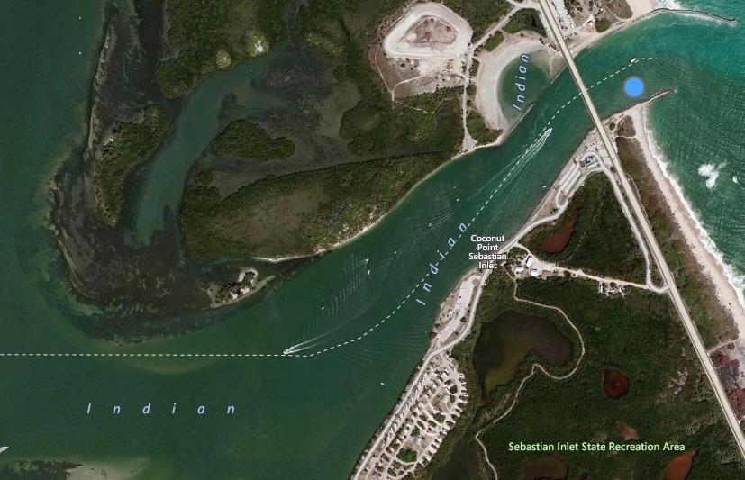
Satellite Views of Sebastian Inlet, FL
Google image of Sebastian Inlet
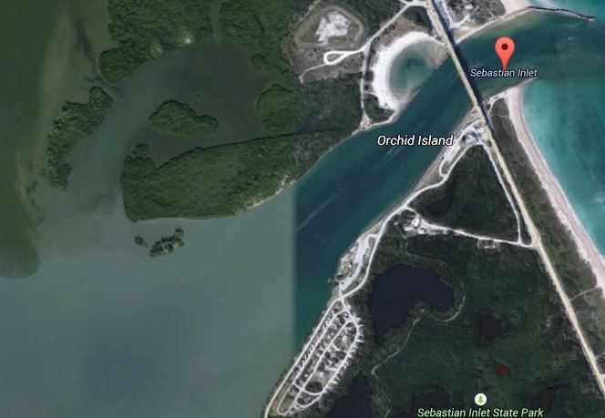
Mapquest image of Sebastian Inlet
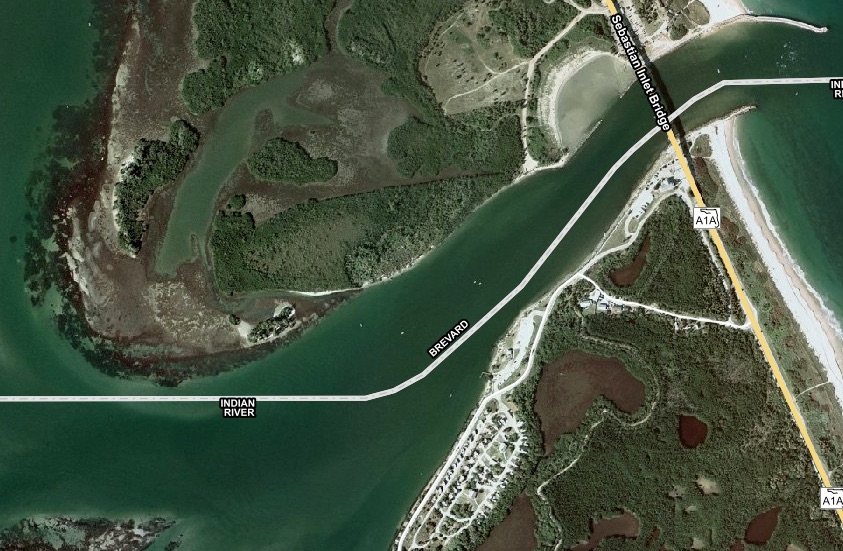
For analyzing Sebastian Inlet and its surrounding flats, my vote currently goes to Bing because its image provides the clearest definition of the bottom contours of the large grass flat that is on the northwestern boundary of the very popular state park known it’s tremendous snook fishing.
And as you can see, the Google map, unfortunately, shows a break in their image which has very clear water in the inlet itself allowing for the best view of the inlet’s bottom contours, but the left half shows an image taken either at a different time when the water was unfortunately very murky so it is not as useful as the other two for the west side of the inlet.
Note: This Google image was pulled on 6-12-2015, and this hard break in the map was not there when I reviewed it our a few months ago during a training course for our Insider Plus clients… it showed a clear view of the entire area just a few months ago.
The Best Satellite Map For Fishing Is…
I could go on for days showing the difference of Google vs. Mapquest vs. Bing maps for specific areas, but the “best satellite map for inshore fishing” technically depends on exactly what spot you’re looking at and how the conditions were when the images from these three services were taken.
Also, the results can fluctuate over time as well since all three services update their images… like the Google image update from the image above to the training course filmed just a few months prior.
So the answer to the “best satellite map for inshore fishing” question is… All of them.
Here are the steps:
- If you’re going to fish a new area for the very first time, start with whichever online map service you’re most comfortable using.
- Then, pull up at least one of the other online maps to check out a spot that may be unclear and/or to double-check that the structure/contour of interest shows up in more than just the one image so you know it’s truly there.
- Then, if you really want to analyze a spot, pull up a 3rd online maps and triple check the area. You just never know when one of the satellite images might reveal something amazing…
Are you tired of fishing the same old spots over and over again?
Then watch this FREE webinar training where you will discover how to find the best inshore spots in your area.
Register here now (before the webinar goes down)!
BONUS BENEFIT [VIDEO]
My favorite aspect of satellite maps is that they show everything… meaning that they don’t just give you a heads up to what you’ll likely see while out on the water. Instead, they take it to the next level and show you areas that you’d never find when searching from the water.
So my absolute favorite thing to look for in online satellite maps in hidden bays, lakes, and ponds that cannot be seen from the land or by water.
I’ve been doing this for about 8 years now, and have been blown away by how many small mangrove lakes there are that can be accessed by adventure-seeking kayakers and/or paddle boarders… many of which offer great fishing!
Here’s a video of a spot that I found shortly after moving to the Tampa area.
It’s the ultimate type of hidden lake… meaning that you can only get in by walking your craft over land.
Conclusion
Satellite maps can give an angler who knows how to read them a huge advantage. With the valuable information these maps provide, you can find great new fishing spots from the convenience of your home… whenever you have a spare 5 or 10 minutes.
And just as important, you can weed out spots that don’t offer either underwater structure or good bottom contours so you don’t waste your valuable time on the water in spots that are most likely not going to hold good fish.
Best of all, there are multiple great options to get a wealth of valuable data online from services that are completely FREE and very easy to use… my favorites are:
- Mapquest
- Bing
Which one is your favorite?
Let me know in the comments.
Related Post: How To Find The Best Inshore Spots In Your Area
Are you tired of fishing the same old spots over and over again?
Then watch this FREE webinar training where you will discover how to find the best inshore spots in your area.
Register here now (before the webinar goes down)!
P.S. – If you think your angler friends or fishing networks would enjoy seeing this, please Tag them or Share this with them. You Rock! Pa-POW!
Fish On!
Related categories:
STOP WASTING TIME ON THE WATER!
Do what the “SMART ANGLERS” are doing and join the Insider Club.
Here’s what you’ll receive today when you join:
- Weekly fishing reports and TRENDS revealing exactly where you should fish ever trip
- Weekly “spot dissection” videos that walk you through all the best spots in your area
- Exclusive fishing tips from the PROS you can’t find anywhere else
- Everything you need to start catching fish more consistently (regardless if you fish out of a boat, kayak, or land).
STOP WASTING TIME ON THE WATER!
Do what the “SMART ANGLERS” are doing and join the Insider Club.
Here’s what you’ll receive today when you join:
- Weekly fishing reports and TRENDS revealing exactly where you should fish every trip
- Weekly “spot dissection” videos that walk you through all the best spots in your area
- Exclusive fishing tips from the PROS you can’t find anywhere else
- Everything you need to start catching fish more consistently (regardless if you fish out of a boat, kayak, or land).




Give you Guys one more tip. Try your local county Interactive GIS maps. Mostly used for tax purpose but a lot of county hire air planes to take photos of all the land every other year. I am Minnesota based and 10,000+ lakes most counties have online access to that photo’s PLUS you can see whats public land for access to those little lakes. (cuz the GIS map has all the tax data and parcel records )
Thanks for making time to leave the helpful suggestion Jeremy!
Jeremy, thanks for this tip. I’ve studied the google/bing/mapquest pictures for a known fish hole alongside a sandbar off the river in my town and they don’t come at all close to the clarity of my tax assessor’s GIS mapping. literally night and day — this is going to come in very handy for me, thanks again!
I want find the fishing spots in persian/arabian gulf near Asalloyeh till Taheri with 20 mails distance to beach
It’s not working on my iPad. Chat window blocks page,no Pensacola info,can’t find spots
Hey Robert, can you please help me understand which chat window you’re referring to by sending a screenshot to Luke@saltstrong.com
As for not being able to find spots, are you referring to the use of the online maps mentioned in this article? If yes, which ones?
Great information, as all of them I have watched so far. I grew up rod and reel fishing for catfish in the rivers and lakes of central Texas. With the occasional unproductive trip to the coast. I now live an hour from saltwater and for the last year or so I make at least two trips a week. Its been a lot of trial and error using the same tactics for locating fish as I did for catfish. They are very similar in the ways of using currents, structure, and food sources to find fish. I have been getting a little more consistent but, with the vast amount of knowledge you guys are sharing. I have went from catching my limit of trout and a red or flounder in a full day of hard fishing. To catching all that plus and being back home by noon. I have been using the satellite maps for quite awhile even fishing freshwater. Recently I came across a site called Zoom Earth. You can Zoom in and out from nearly realtime satellite views, that really aren’t very helpful. And scroll back to views I think 2005 all of the same location. You can get many different views without changing maps. Not all locations I have looked at go back as far, there might be some that go back further, but they all have had several views. Anyhow, I thought I would pass this info on. You guys are doing a hell of a job. I’m a little envious, ya’ll are living a dream. This site has a wealth of knowledge any fisherman or woman could benefit from. Thanks guys.
Thanks for making time to leave the nice and helpful comment James! So glad to see that you’re enjoying the site. I’ll be sure to check out the Zoom Earth platform. Tight Lines!
This article, like all your others, is so informative! Thanks so much for all the education! I especially appreciate the message that the most important thing is to figure out where the fish are first. I live in Ecuador, S. America and will be fishing the mangroves near Guayaquil. The maps don’t seem to be as revealing as the clear, shallow waters of Florida! Any way these maps could still give me clues about where to fish?? Example: https://earth.app.goo.gl/?apn=com.google.earth&ibi=com.google.b612&isi=293622097&ius=googleearth&link=https%3a%2f%2fearth.google.com%2fweb%2f%40-2.20822543,-79.98504526,2.67092384a,5554.56953786d,35y,0.00000004h,0.707673t,-0r Any suggestions are very much appreciated!
ALthough I’ve used google satellite maps to look for boat ramp and shoreline, I never considered using it to look for structure and current. Great article, I’m going to try this on the Chesapeake Bay and next time I’m in Tampa. Thanks for the tip!
Glad to see that you enjoyed this Satellite map article. They sure can be helpful for finding new fishing spots in shallow water areas. Hopefully it works as good in Chesapeake Bay as it does down here in Tampa. Fish On!
I am using the new Google Earth and it no longer has a lot of the features the older versions had such as “historical view”. An other issue to be aware of is not all the imagery displayed is current. I have been using Google Earth, (and Google Maps), for investigating the New Jersey surf and I have noticed that the Google Earth image is almost a year out of date.
Nice! Thanks.
Anything that makes me smarter than a fish is a good thing!
I use Google Earth, which is free. It has a feature which shows the same picture over time (go to ‘View’, then ‘Historical Imagery’).
In the same way that you suggest using all three maps to compare on location, the Google Earth View shows pictures taken on different days. The distortion of a cloudy day or a reflection will likely change. On many locations, I can get 5-6 views over time, as much as over 10 years.
And that has been the real bonus. In many cases, earlier photos can give you a ‘tell’: a cut or hole that may still be around; or how a bar, swash, or eddy has changed.
The value of maps is huge, particularly when you go to new places. The time spent to advance scout means less running and more casting.
As always guys, thanks for showing us how to fish better ‘from the neck up’.
This is a great article and discussion. I use both Bing and Google in the Edgewater and Mosquito Lagoon areas. I do a lot of kayaking. A few months ago I caught a 47 inch bull red east of the ramp near Marker 42 Mosquito Lagoon.
I have been laid up recovering from back surgery since June 14th. I joined the Insider and really like watching all the Insider videos. Can’t wait to get back out on the water.
Salt Strong is great.
Glad to see that you enjoyed this post as well as the Insider Fishing Club platform. Congrats on the big redfish catch. Keep up the great work!