#1 App For Offshore Fishing [Wrecks, Reefs, Satellite Mapping & MORE!!!]
- By: Wyatt Parcel
- on
We designed the BEST app for offshore fishing!!
How do you know what’s underneath your boat on an offshore fishing trip?
Is there a way to view all of the underwater wrecks and structure dozens of feet underwater?
Check this out!!
#1 App For Offshore Fishing [VIDEO]


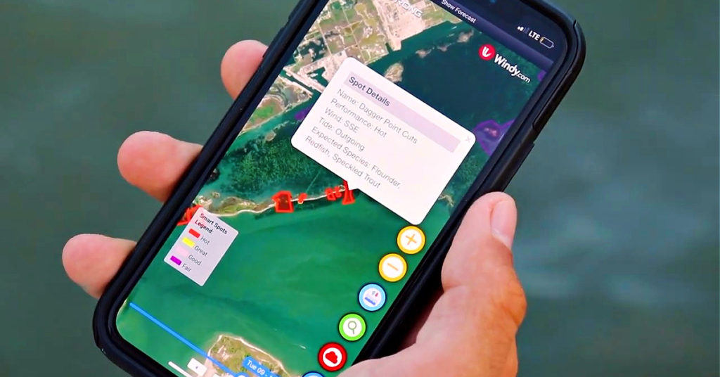
Smart Fishing Spots is a platform we designed specifically for our Insider Club Members.
It is an all-in-one app for saltwater anglers that provides, the tides, winds, as well as radar and sonar mapping on top of the Smart Spots feature that reveals fishing hotspots.
If you are already an Insider Member, then you’ve already got FREE access to Smart Fishing Spots.
Join the Insider Club today to start planning your trips with Smart Fishing Spots.
Weather Forecasts
When you go fishing offshore, you need to know the wind direction but more importantly the wind speed.
It is important to know if the wind will pick up as the day goes on or if it changes direction.
Within Smart Fishing Spots, the heavier winds are indicated by brighter green colors and calmer areas in light blue.
The white lines across the screen indicate wind direction and speed.
Furthermore, if you click the drop-down menu at the top, you will reveal the entire 10-day forecast.
You can further click within each day and get an hour-by-hour weather forecast so you are in tune with any changes.
Additionally, you can take a look at the wave height and direction throughout the day using the toggle button at the bottom of the screen.
This is a super useful tool to help you plan your trips around the weather so you can anticipate the forecast ahead of time.
There are endless weather features with more coming each week!
Artificial Reef Finder
The artificial reef data we’ve been able to access stretches from Texas all the way up to the Carolinas going to Virginia.
We are actively looking to add all states up and down the east coast.
To locate reefs in your area, you have to click the “Artificial Reefs” function and zoom into an area you want to fish.
You’ll see scattered dots that indicate artificial reefs or shipwrecks.
Moreover, you can even click into each reef and read additional data about how that reef came to be.
There you will see the exact Latitude/Longitude coordinates for that wreck.
Remember, you will have to zoom into areas along the coastline to see each wreck and reef.
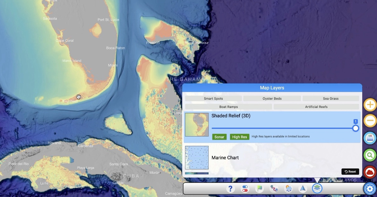
Shaded Relief (3D) Map Layer
This is the BEST tool I’ve found for planning an offshore trip around fishing different bottom structures.
Just by playing around with Smart Fishing Spots and jumping around from spot to spot, you can see the different bottom contours from the Gulf to the Carolinas.
You can find rocks, ledges, and structure you would NEVER know was even there!!!
Routes & Tracks Feature
Furthermore, once you have the coordinates for where you want to fish, you can use our Routes & Tracks tool to navigate your way there.
You can click on your starting point and further map out waypoints to create a route for your trip.
Before even getting out on the water, you can look at exactly where you want to fish and what the structure will look like.
Marine Chart
Another map layer that I find incredibly helpful is the Marine Chart Layer.
It is very similar to the Shaded Relief Layer but different in that you can get a super fast view of depths and drop-offs.
Also, there are important indicators and markings on the Marine Chart for boaters that may not appear on other map layers.
Conclusion
There is SO MUCH already at your fingertips with Smart Fishing Spots and even MORE to look forward to down the road!
If you do lots of offshore or nearshore fishing, then you NEED this app.
It will completely transform the way you fish.


Do you have any additional questions about the best app for offshore fishing?
Please ask any questions or suggestions you have for Smart Fishing Spots down in the comments!!!
If you know someone who wants to learn more about the best app for offshore fishing, please TAG or SHARE this with them!
Oh, and if you Join the Insider Club TODAY, Smart Fishing Spots is absolutely FREE! Click here to join us in the Insider Club!
Related Articles:
Related categories:
STOP WASTING TIME ON THE WATER!
Do what the “SMART ANGLERS” are doing and join the Insider Club.
Here’s what you’ll receive today when you join:
- Weekly fishing reports and TRENDS revealing exactly where you should fish every trip
- Weekly “spot dissection” videos that walk you through all the best spots in your area
- Exclusive fishing tips from the PROS you can’t find anywhere else
- Everything you need to start catching fish more consistently (regardless if you fish out of a boat, kayak, or land).


is there a lot of data in the CA area?
My app only works on Wi-Fi. Smart spots, oyster beds, grass flats all pop up when on Wi-Fi. As soon as I’m off, they don’t pop up on the app. They stopped doing it all of the sudden when I installed a update on my iPhone.
My area is mainly Alabama. When I click on an artificial reef inshore or offshore it does NOT pop up with the detailed information that shows up in your video. Why ?
Alabama has limited data for their reef and wreck coordinates. We gather what data we can, but unfortunately other data is limited to what’s published by the State or organization that published the data
I assume you mean that Alabama does not have the data in down loadable format ??
Do you know if Alabama is working on this ?
Is there a contact person at the State ?
Wyatt , go to the website Outdoor Alabama and it has all of the reefs in down load format for nearshore , inshore and other info. You can also just search for Alabama fishing reefs and the link to Outdoor Alabama Artificial Reefs will come up.
Does saltstrong cover ocean city Md off shore reefs and wrecks
We currently have wreck data near the Chesapeake but are still constantly updating info as it is released.
Does the siftware cover Western Australia?
Unfortunately we are just in the US right now.